Trail Bicycle tourism Les Rousses - LES ROUSSES - LAC DE JOUX ET ROMAINMOTIER - Photo

LES ROUSSES - LAC DE JOUX ET ROMAINMOTIER

© OpenStreetMap contributors
Length
Length
92 km
Max alt
Max alt
1191 m
Uphill gradient
Uphill gradient
1388 m
Km-Effort
Km-Effort  
110 km
Min alt
Min alt
663 m
Downhill gradient
Downhill gradient
1420 m
Boucle
Boucle
No
Creation date :
2023-06-25 07:04:06.542
Updated on :
2023-06-25 15:06:17.3

(0 Reviews)

Bicycle tourism
Bicycle tourism
7h13
Difficulty : Difficult

Scan this QR Code to open this trail in the SityTrail application

FREE GPS app for hiking

Logo SityTrail SityTrail

IGN / Geographical institutes

Download SityTrail from the App Store Download SityTrail from Google Play

Logo SityTrail SityTrail World

The world is yours!

Download SityTrail from the App Store Download SityTrail from Google Play Download SityTrail on Huawei AppGallery

About

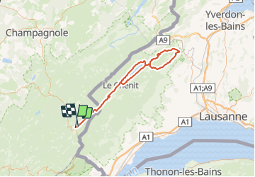
Trail Bicycle tourism of 92 km to be discovered at Bourgogne-Franche-Comté, Jura, Les Rousses. This trail is proposed by jean-marie.parachini.

Description

circuit au départ des Rousses vers Bois d'amont puis côté Suisse le long du lac de Joux et boucle par Romainmotier et retour au bout du lac à Le Pont.
retour par lac de Joux et lac des Rousses.

Elevation profile

Photos

Positioning

Country:
France
Region :
Bourgogne-Franche-Comté
Department/Province :
Jura
Municipality :
Les Rousses
Location:
Unknown
Start:(UTM)
274255 ; 5152869 (32T) N.

Trails nearby

Trail Cycle  - Lac de Lamoura et Valserine - Prémanon - Photo
Cycle
tracegps

Cycle

Medium
(1)
, Bourgogne-Franche-Comté, Jura, France
39 km | 49 km-effort
2h 0min
Yes
Trail Walking  - Le Belvédère des Maquisards - Prémanon - Photo
Walking
tracegps

Walking

Medium
(1)
, Bourgogne-Franche-Comté, Jura, France
5.4 km | 7.8 km-effort
2h 0min
Yes
Trail Walking  - Autour de Prémanon - Photo
Walking
tracegps

Walking

Very difficult
(1)
, Bourgogne-Franche-Comté, Jura, France
18 km | 27 km-effort
6h 0min
Yes
Trail Walking Les Rousses - Le Noirmont - Les Rousses - Photo
Walking
tracegps

Walking

Very difficult
(2)
Les Rousses, Bourgogne-Franche-Comté, Jura, France
15.1 km | 23 km-effort
6h 0min
Yes
Trail On foot  - Les Arcets - Photo
On foot
PRO

On foot

Easy
, Bourgogne-Franche-Comté, Jura, France
9 km | 13.6 km-effort
3h 5min
Yes
Trail Walking  - Prémanon, Mont Fier  - Photo
Walking
MoiClaude

Walking

Very easy
(1)
, Bourgogne-Franche-Comté, Jura, France
10.9 km | 15.8 km-effort
2h 34min
No
Trail Snowshoes Les Rousses - Lac des Rousses  - Photo
Snowshoes
nfranche

Snowshoes

Medium
(1)
Les Rousses, Bourgogne-Franche-Comté, Jura, France
13.8 km | 18.4 km-effort
4h 15min
Yes
Trail Walking Les Rousses - Noirmont et Creux du Croue - Photo
Walking
DanElise

Walking

Very easy
(1)
Les Rousses, Bourgogne-Franche-Comté, Jura, France
12.2 km | 19.8 km-effort
4h 18min
Yes
Trail Bicycle tourism Les Rousses - LES ROUSSES - SAINT CLAUDE  - Photo
Bicycle tourism
jean-marie.parachini

Bicycle tourism

Difficult
Les Rousses, Bourgogne-Franche-Comté, Jura, France
69 km | 88 km-effort
6h 15min
No


Close
My subscriptions